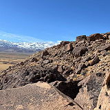
Sad Boulders is a popular climbing area located in the Buttermilk Country just outside of Bishop, California. Known for its stunning granite boulders and picturesque surroundings, Sad Boulders offer a wide variety of climbing routes suitable for climbers of all skill levels. The area got its name from the unique shapes and formations of some of the boulders, which can resemble sad or drooping faces when viewed from certain angles.
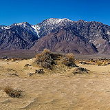
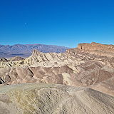
Death Valley National Park is a vast desert wilderness located in eastern California, United States. It is one of the largest national parks in the country, covering over 3.4 million acres of rugged mountains, expansive sand dunes, and vast salt flats.
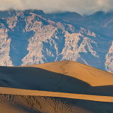
The Mesquite Flat Sand Dunes are a popular attraction located in Death Valley National Park, California, United States. They are one of the largest sand dune complexes in the park, covering an area of over 14 square miles.
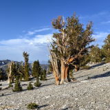
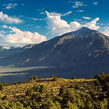
The Ancient Bristlecone Pine Forest is a renowned natural attraction located near Bishop, California, in the White Mountains of eastern California. The forest is part of the Inyo National Forest and is managed by the United States Forest Service. This forest is famous for its ancient bristlecone pine trees, some of which are among the oldest living organisms on Earth.
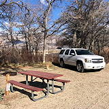
Taboose Creek Campground is a campsite located in the Inyo National Forest, approximately 15 miles west of Independence, California, in the eastern Sierra Nevada mountain range. It offers a beautiful natural setting and access to outdoor recreational activities in the surrounding area. Independence is a small town in the Owens Valley region of California, known for its proximity to the Sierra Nevada Mountains.
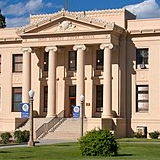
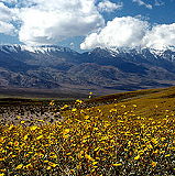
Independence is a small town located in Inyo County, California, in the eastern part of the state. It is situated in the Owens Valley, a region nestled between the Eastern Sierra Nevada mountain range to the west and the White Mountains to the east. It's located on U.S. Route 395, making it a stop for travelers exploring the Eastern Sierra and surrounding areas. The population was 669 in 2010.
Olancha Peak is a prominent mountain located in the Sierra Nevada mountain range of California, in Inyo County, California. It is approximately 50 miles south of Lone Pine and Independence and is easily visible from the Owens Valley. Olancha Peak has an elevation of 12,123 feet (3,695 meters) above sea level, making it one of the notable peaks in the Southern Sierra Nevada.
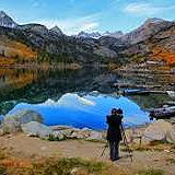
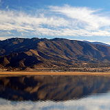
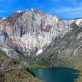
Lake Sabrina is a scenic alpine lake located in the Eastern Sierra region of Inyo National Forest, in the eastern part of Inyo County, in the eastern Sierra Nevada mountains of California. It is near the town of Bishop and is part of the Inyo National Forest. It is known for its stunning mountain scenery, clear waters, and recreational opportunities.
Darwin is a small, remote town located in eastern California, USA. It is situated in Inyo County, near the western edge of the Death Valley National Park, one of the hottest and driest places in North America. The population was 36 at the 2020 census, down from 43 at the 2010 census.
Furnace Creek is a small desert oasis located in Death Valley National Park, California, USA. It is one of the hottest and driest places in North America and the world. Furnace Creek is situated within Death Valley, which is part of the Mojave Desert in eastern California. It is located in Inyo County, near the Nevada border. The population was 136 at the 2020 census, up from 24 at the 2010 census.
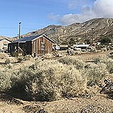
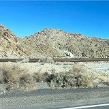
Homewood Canyon is a remote and sparsely populated area located in Inyo County, California, in the eastern part of the state. It is situated in the eastern Sierra Nevada region, not too far from the Nevada border. Homewood Canyon sits at an elevation of 3,074 feet (937 m). The 2010 United States census reported Homewood Canyon's population was 44.
Mesa is a census-designated place in Inyo County, California, United States. The population was 251 at the 2010 census, up from 214 at the 2000 census. Inyo County is known for its beautiful and varied landscapes, including parts of the Eastern Sierra Nevada, Death Valley National Park, and other natural attractions.
Cartago is a small unincorporated community located in Inyo County, California, USA. It is situated in the eastern part of the state, near the eastern border of California, not far from the Nevada state line. The population was 62 at the 2020 census, down from 92 at the 2010 census.
Dixon Lane-Meadow Creek is a census-designated place located in Fresno County, California, in the San Joaquin Valley region. It is east of the city of Fresno and is part of the larger Fresno metropolitan area. The population was 2,780 at the 2020 census, up from 2,645 at the 2010 census.
Lone Pine is a small town located in eastern California, USA. It is known for its stunning natural surroundings, particularly the nearby Sierra Nevada mountain range and the tallest peak in the contiguous United States, Mount Whitney. Lone Pine is a small town with a relatively small population of 2,035 at the 2010 census, known for its close-knit community and outdoor-oriented lifestyle.
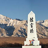
Manzanar is a historic site located in the Owens Valley of California, United States. It was the site of one of ten internment camps where Japanese Americans were forcibly relocated and detained during World War II.
Inyo County is a county located in the eastern part of California, United States. It is known for its spectacular natural beauty and is home to several national parks and wilderness areas, including Death Valley National Park, Mount Whitney, and the Ancient Bristlecone Pine Forest. In the 2020 census, the population was 19,016. The county seat is Independence.
Inyo National Forest is your gateway to the Eastern Sierra. Extending along the California and Nevada border Inyo National Forest is a land of superlatives – tall mountains, old trees, Mono Lake and iconic views, with a diversity of recreation opportunities to match.
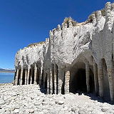
Crowley Lake Stone Columns were created by Eons old volcanic activity. These amazing formations are in the shape of helical columns. The stone columns are up to 20 feet tall and are connected by fortified stone arches.
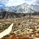
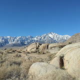
The Alabama Hills are a formation of rounded rocks and eroded hills set at the base of the jagged peaks of the Sierra Nevada. Both geologic features were shaped by the same uplifting occurring 100 million years ago.